Safety of Navigation within Cowes Harbour
03 January 2023
(This notice replaces Local Notices to Mariners 02 of 2016, 16 of 2019 and 04 of 2022 which are hereby cancelled)
Notice is hereby given that the following information is highlighted to all mariners to promote safe navigation within Cowes Harbour:
Cowes Outer and Inner Fairways (see Fig 1)
The Cowes Harbour fairway is divided into two distinct areas: the ‘Outer Fairway’ and the ‘Inner Fairway’.
The Outer Fairway extends 500m north of Nos. 1 and 2 buoys. Small craft should be vigilant for large and regular commercial traffic, which cannot safely navigate outside of the Outer or Inner Fairways. Small craft up to 20m in length may use the Eastern Channel. All vessels must comply with Rule 9 of the Collision Regulations: Navigation in Narrow Channels.
A sailing vessel fitted with an auxiliary engine must proceed with the engine running and ready for immediate use in the Inner Harbour.
When navigating in and around Cowes Harbour, vessels over 20m must, and all vessels are strongly recommended to, maintain a listening watch on VHF Channel 69.
Vessels under 20m, sailing vessels and fishing vessels must give way to large vessels that can only safely navigate within the fairway.
Cowes Breakwater (see Fig 1)
The detached Cowes Breakwater is marked with five GPS-synchronised yellow lights spaced equidistant along the crest displaying flash characteristic Fl.Y.2.5s. The western end, on the Inner Fairway extremity, is marked by a red channel mark Fl.R.2s and the eastern end by a green starboard channel mark Fl.Y.5s. Do not cut inside between these channel marks and the ends of the breakwater; there is limited clearance and obstructions.
Stay at least 30m from the breakwater crest because the rock-armoured structure extends 25m to the north and south. If travelling east-west along the northern side of the breakwater, you may not be visible to craft northbound in the Inner Fairway.
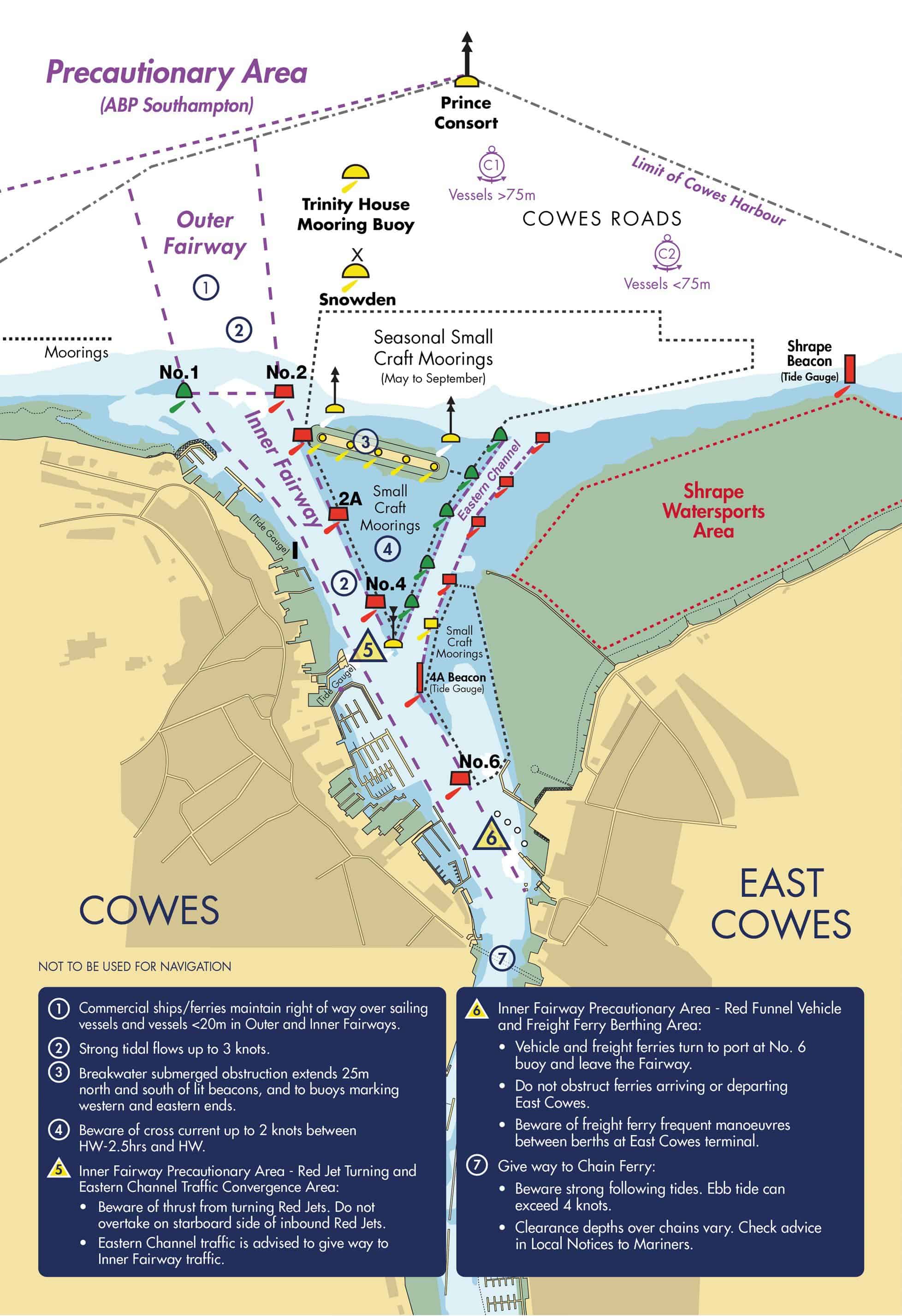
Figure 1: Diagram of Cowes Outer and Inner Fairways and cautions.
Inner Harbour Cross Current (see Fig 2)
Between HW-2.5hrs to HW, vessels transiting the Inner Fairway between No. 2A buoy and No. 4A beacon may experience a westerly-setting cross-current of up to 2 knots at spring tides, which has a tendency to set vessels down towards the western shore.
Small craft transiting between No. 2A buoy and No. 4A beacon should be prepared to alter their heading so as not to be set westwards across the fairway and should avoid impeding the safe passage of commercial shipping and ferries.
At the Chain Ferry, the flood tide can reach 2.5 knots between HW-2.5hrs and HW at spring tides. The ebb tide can reach 4 knots between LW-3hrs and LW at spring tides. See Local Notice to Mariners: Tidal Flows in Cowes Harbour.
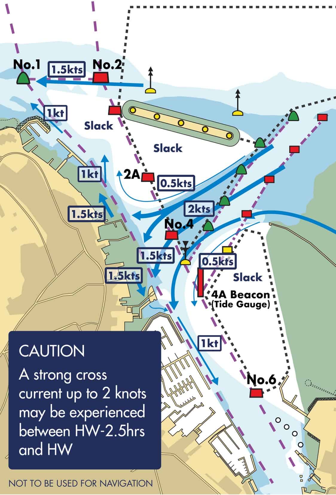
Figure 2: Cross current at HW -2hrs
Eastern Channel (see Fig 3)
Vessels less than 20m in length, approaching or departing Cowes from/to the north or east may use the Eastern Channel to avoid the busy main harbour entrance, thereby de-conflicting with the larger commercial vessels and provided that there is sufficient water in relation to their draught. The Eastern Channel is dredged to a depth of 2.25m below chart datum and tide gauges are located at either end of the channel on the Shrape Beacon and 4A Beacon. Mariners are advised that shallow water lays either side of the channel until passing north of the Cowes Breakwater.
Vessels in the Eastern Channel must adhere to the harbour speed limit of 6 knots through the water and no wash. Vessels joining or leaving the Eastern Channel are advised to give way to all vessels navigating in the Inner Fairway.
A west-southwesterly current of up to 2 knots during spring tides may be experienced between HW-2.5hrs and HW, west of the Shrape Breakwater. A north-westerly current of up to 1.5 knots during spring tides may be experienced from HW+3hrs to HW+5hrs, west of the Shrape Breakwater. Caution should be exercised so as to not be set into the path of other vessels using the Eastern Channel or vessels navigating in the Inner Fairway.
Vessels shall not bypass the Eastern Channel or fairway approaches by ‘cutting-through’ the small craft mooring areas; such action is associated with much risk because of the concentration of unlit moorings and moored vessels in this area. See Local Notice to Mariners: Eastern Channel.
Shrape Watersports Area (see Fig 3)
The Shrape Watersports Area is used by sailing schools for pupils under instruction and should, wherever possible, be avoided by vessels not engaged in supervised activity. See Local Notice to Mariners: Shrape Watersports Area.
Figure 3: Eastern Channel and Shrape Watersports Area
Cowes Inner Fairway Precautionary Areas (See Fig 4)
Mariners’ attention is brought to the two Precautionary Areas in the Cowes Inner Fairway.
The Red Jet turning & Eastern Channel Traffic Convergence Area is used by the Red Jet High Speed passenger ferry for executing a 180° turn prior to berthing alongside Jubilee Pontoon at Cowes Town Quay. Significant wash is generated by the ferry during this manoeuvre. Additionally, craft using the Eastern Channel will be merging into or diverging out of the Inner Fairway in this area.
The Red Funnel Vehicle & Freight Ferry Berthing Area is used by the Red Funnel freight ferry to manoeuvre between the linkspan at the East Cowes Red Funnel Terminal berth and the lay-by berth and vice-versa to allow safe access and egress for the Red Funnel vehicle ferry.
All vessels should navigate with particular caution in and around these areas and not impede the safe passage of the ferries.
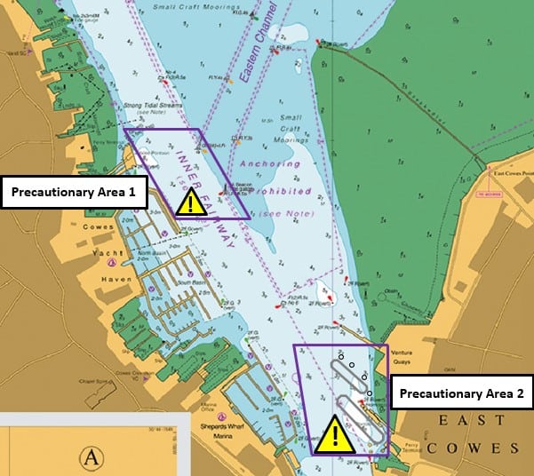
Figure 4: Inner Harbour Precautionary Areas
Speed Limit and Wash (See Fig 5)
All craft must comply with the speed limit and wash regulations in Cowes Harbour. The speed limit in the Inner Harbour is 6 knots through the water. This limit applies within the Cowes Harbour jurisdiction, which includes the area within 100m of the Mean High Water Mark west and east of the harbour entrance as far as Egypt Point and Old Castle Point. Additionally, do not create wash in the Inner Harbour and within 100m of the shore from Egypt Point to Old Castle Point. See Local Notice to Mariners: Speed Limit and Wash in Cowes.
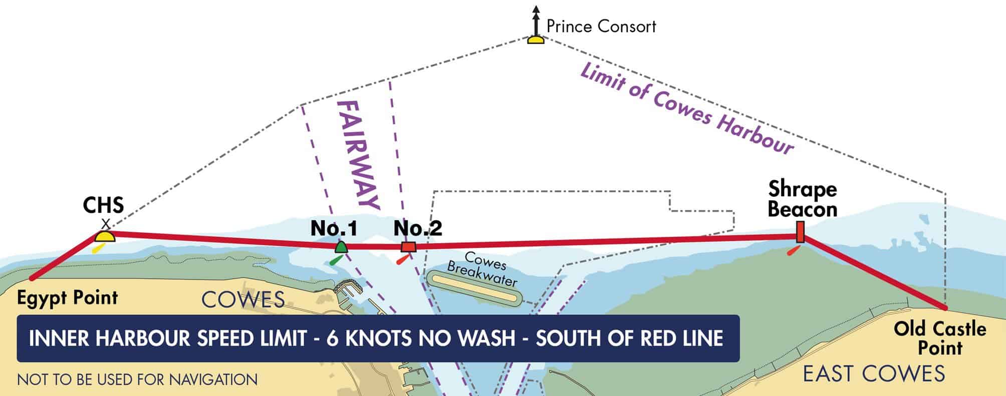
Figure 5: Inner Harbour speed limit applies south of red line, maximum 6kts and no wash
Cowes Chain Ferry (See Fig 6)
The Chain Ferry has right of way over all river traffic. Vessels requiring an unimpeded passage must establish early contact (call sign ‘Cowes Chain Ferry’) and agree on VHF Ch69 which side the ferry will hold. The Chain Ferry is situated on a blind bend at the narrowest stretch of the river. Navigate with caution when approaching the ferry, particularly with a following tide. The tidal flow generally accelerates as you approach the ferry due to the river narrowing, which may set you down towards the ferry quicker than you initially anticipated. Give way in good time. See Local Notice to Mariners: Cowes Chain Ferry.
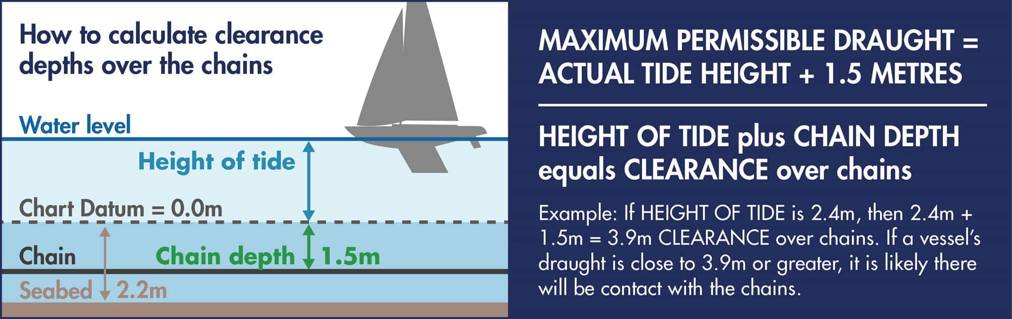
Figure 6: Calculating clearance depths over the chains
Departing a Marina or Moorings
Vessels leaving a marina area or moorings should always give way to vessels navigating within the fairways.
Reporting of Incidents and Accidents
Any incident or accident that reflects on the safe operation of the harbour is to be reported immediately to the Harbour Master, including damage to vessels, navigation marks or harbour structures, close quarters situations and ‘near-miss’ incidents. Harbour users are encouraged to submit accidents, incidents and potential risk reports using the incident report form on the harbour website. See Local Notice to Mariners: Reporting of Damage, Incidents and Potential Risk.
Navigation in the Inner Harbour Small Craft Mooring Areas
Mariners should not navigate a power-driven vessel or sailing vessel fitted with an auxiliary engine within the Small Craft Mooring Areas in the Inner Harbour south of the Cowes Breakwater, unless proceeding to or from a mooring located within that area.
No Anchoring Areas
Vessels must not anchor in the fairways, Eastern Channel, and in any of the areas containing small craft moorings due to the presence of ground chains.
Mariners are advised to refer to the navigational charts for the area, including UKHO chart 2793 ‘Cowes Harbour and River Medina’.
This Local Notice to Mariners shall remain in force until further notice.