This Notice replaces Local Notices to Mariners Nos. 28(T) of 2020 and 10 of 2019, which are hereby cancelled.
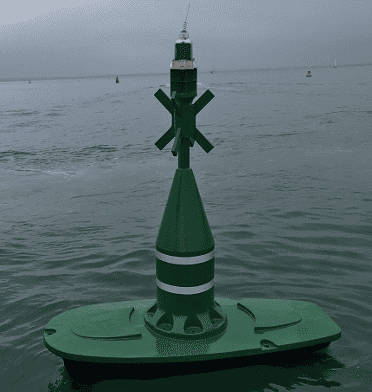
Notice is hereby given that the yellow EC9 special mark buoy in the Cowes Harbour Eastern Channel at position approximate 50° 45.850’ N 001° 17.635’ W has been replaced by a starboard channel mark in the same position. The new starboard channel mark retains the charted name of EC9 and has the light characteristic Fl.G.10s. See Figure 1.
Figure 1: New EC9 starboard channel mark
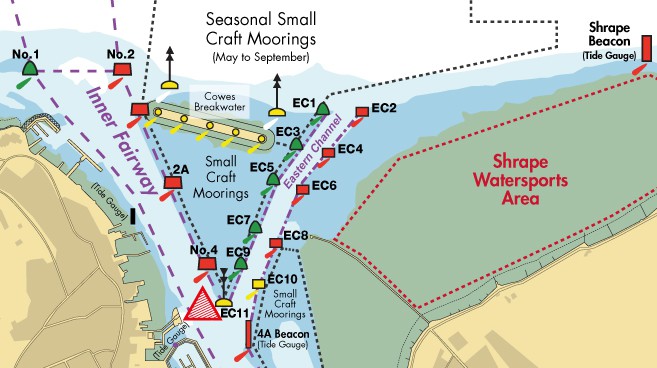
The dredged Eastern Channel connects the eastern approaches to Cowes with the Inner Fairway. This enables small vessels up to 20m in length to avoid the busy main harbour entrance when arriving or departing Cowes from/to the north and east, thereby de-conflicting with the larger commercial vessels. See Figure 2.
Vessels in the Eastern Channel must adhere to the harbour speed limit of 6 knots through the water and no wash.
Vessels joining or leaving the Eastern Channel are advised to give way to all vessels navigating in the Inner Fairway.
Figure 2: Eastern Channel buoyage. Red triangle indicates Inner Harbour Precautionary Area: Red Jet Turning & Eastern Channel Traffic Convergence Area
Eastern Channel buoyage, lights and positions:
Station
Colour
Type
Light Characteristic
Lat. (N)
Long. (W)
EC1
Green
Buoy
Fl.G.3s
50º 46.020′
001º 17.465′
EC2
Red
Buoy
Fl.R.3s
50º 46.020′
001º 17.418′
EC3
Green
Buoy
Fl.G.5s
50º 45.985′
001º 17.512′
EC4
Red
Buoy
Fl.R.5s
50º 45.980′
001º 17.478′
EC5
Green
Buoy
Fl.G.2s
50º 45.946′
001º 17.567′
EC6
Red
Buoy
Fl.R.2s
50º 45.936′
001º 17.536′
EC7
Green
Buoy
Fl.G.4s
50º 45.900′
001º 17.600′
EC8
Red
Buoy
Fl.R.4s
50º 45.869′
001º 17.580′
EC9
Green
Float (Stbd)
Fl.G.10s
50º 45.850′
001º 17.635′
EC10
Yellow
Buoy (Port)
Fl.Y.3s
50º 45.798′
001º 17.627′
EC11
Yellow-Black
S. Cardinal Buoy
Q(6) + LFl(1)
50º 45.800′
001º 17.668′
4A Beacon
Red
Pile
LFl.R.5s
50º 45.757′
001º 17.630′
Channel depth/width The dredged depth in the Eastern Channel is 2.25 metres below chart datum, therefore the minimum depth of water in the channel is equal to the height of tide + 2.25m. Small vessels may use the Eastern Channel provided there is sufficient water in relation to their draught.
Tide gauges are located on the Shrape Beacon and 4A Beacon (see Figure 2).
The channel is, at its narrowest, 35m wide. Mariners are advised that shallow water lays either side of the channel until passing north of the Cowes Breakwater.
Red Jet Turning & Eastern Channel Traffic Convergence Area Mariners’ attention is brought to the Inner Fairway Precautionary Area located at the western end of the Eastern Channel (see Figure 2). This area is used by the Red Jet High Speed passenger ferry for executing a 180° turn prior to berthing alongside Jubilee Pontoon at Cowes Town Quay. Significant wash is generated at the stern of the ferry during this manoeuvre. Vessels using the Eastern Channel will be merging into or diverging out of the Inner Fairway in this area. Eastern Channel traffic is advised to give way to Inner Fairway traffic.
Rule 9 Mariners must ensure that Rule 9 of the Collision Regulations is complied with. Particular care should be taken to avoid impeding commercial vessels in the Inner Fairway, this includes passenger ferries (Red Jets) turning off Cowes Town Quay and large vehicle and freight ferries approaching and departing from East Cowes Red Funnel Terminal. Cross current A west-southwesterly current, of up to 2kts during spring tides, may be experienced between HW-2.5hrs and HW, west of the Shrape Breakwater.
A northwesterly current, of up to 1.5kts during spring tides, may be experienced from HW +3hrs to HW +5hrs, west of the Shrape Breakwater.
Caution should be exercised so as to not be set into the path of other vessels using the Eastern Channel or vessels navigating in the Inner Fairway. Small craft moorings Care should be taken to adhere to the buoyed channel and not to enter the ‘small craft moorings’ (see Figure 2); these are prohibited areas. Shrape Watersports Area The area to the east of the Shrape breakwater has been designated a watersports area and vessels not using the area should ensure they remain well clear.
This website uses cookies so that we can provide you with the best user experience possible. Cookie information is stored in your browser and performs functions such as recognising you when you return to our website and helping our team to understand which sections of the website you find most interesting and useful.
Strictly Necessary Cookies
Strictly Necessary Cookie should be enabled at all times so that we can save your preferences for cookie settings.
If you disable this cookie, we will not be able to save your preferences. This means that every time you visit this website you will need to enable or disable cookies again.
3rd Party Cookies
This website uses Google Analytics to collect anonymous information such as the number of visitors to the site, and the most popular pages.
Keeping this cookie enabled helps us to improve our website.
Please enable Strictly Necessary Cookies first so that we can save your preferences!