All sailors and boaters will be well aware of the periodic phenomenon of the tides, one of the most reliable phenomena in the world. We have received several requests for a specific explanation of tide heights in Cowes Harbour and we hope that the following will be of some assistance.
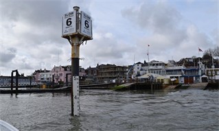
There are five tide gauges (tide boards) within Cowes Harbour; on the Shrape Beacon, at Watch House Slip by the Island Sailing Club, at Cowes Town Quay, a new beacon at the west end of the Small Craft Channel, and at the north end of Medina Wharf opposite East Cowes Marina.
These boards show the height of tide above that shown on the Admiralty Charts. The height on the Admiralty Charts is known as Chart Datum (CD) and this is generally the height of the Lowest Astronomical Tide. The Lowest Astronomical Tide, or LAT, is the height of the water at the lowest possible theoretical tide that can be predicted to occur under average meteorological conditions.

CHC displays the live tide height on our website, and also on our sister site www.COWES.co.uk via an electronic tide gauge which takes a feed from the Environment Agency’s monitoring site located in Cowes Yacht Haven. Mariners are advised to check the physical tide boards in the harbour and not rely solely on the electronic gauge when conducting your passage.
The predicted heights shown in the Cowes tide tables are also the heights above Chart Datum; they are shown for both High Water (HW) and Low Water (LW). The height of HW is influenced in the most part by the gravitational effect of the moon and the sun; when the two are acting together we get spring tides and when they are acting in opposition we get neap tides. During spring tides the HW will be higher and the LW lower; this means that there is a greater range of tide and the tidal flows will be stronger the larger the range between HW and LW.
In Cowes, our Mean High Water Spring (MHWS) tide is 4.2m and our Mean Low Water Spring (MLWS) tide is 0.8m, giving a mean range of 3.4m. The Mean High Water Neap (MHWN) tide is 3.5m and Mean Low Water Neap (MLWN) tide is 1.8m, giving a range of only 1.7m. This means that in Cowes there is double the rise and fall of tide on a mean spring tide compared with a mean neap tide; you can therefore expect approximately double the rate of flow on a mean spring tide compared with a mean neap tide. Of note is the fact that we are currently at the top end of the 18-year lunar cycle which affects all tidal regimes and contributes to the larger tidal ranges and stronger flows that are being experienced at this time. There are other factors that may influence the tidal rate such as the topography and bathymetry of the harbour, but we will not try and explain them in this guide.
The predicted tidal heights are also influenced by the atmospheric pressure, wind conditions, rainfall and occasional tidal surges generally originating from the southern part of the North Sea. The average barometric pressure on the south coast is 1016mb and for every millibar increase we expect the height of tide to be reduced by 1cm; conversely, for every reduction of 1mb we expect to see the predicted tidal height to be increased by 1cm. A prevailing southwesterly wind can also hold the tide up leading to heights above prediction, as can periods of heavy rainfall when rainwater is introduced into the Medina Estuary and the Solent.
