The rich and varied history of the Medina Valley is a source of great interest to many of us who live and work here and also for the large number of visitors to the Island. The focus of interest in the Medina is often its maritime heritage and the long history of sailing, so this month we decided to take a few steps further back to see how the landscape developed into the coast and seascape that we know and enjoy today.
The Isle of Wight as an actual ‘island’ is a relatively recent phenomenon and a full breach of the ‘Wight peninsula’ to become an island occurred approximately 8,000 years ago. Prior to this time the Island would have been connected to the mainland on the western side with the chalk ridge of the Downs connecting to the Isle of Purbeck, and the current Solent being a vast river complex with large tributaries branching from Southampton, Christchurch and Poole.
During the Pleistocene period (2.58 million years to 11,700 years ago) average surface temperatures were roughly 4-5 degrees lower than they are today, which led to a large amount of water being locked up as frozen deposits on land (the ice ages). With less water in the oceans, sea levels were much lower than at present and so the extent of the Island would have been much greater than it is today, restricting the Solent to a moderate sized river.
Fluctuating sea levels during the glacials and interglacials of the Pleistocene would have altered the profile of the low-lying extremities of the Solent river system. During the Ipswichian interglacial (approximately 150-100 thousand years ago), this resulted in a much larger mud flat and gravel complex being created at Newtown, a raised beach platform at Bembridge, and altered river systems at West Wight.
During the Ipswichian, the extent of the Medina was much wider than it is today, with river gravels extending to higher grounds. The gravels not only show the former reach of the rivers, but also reflect some of the Island’s early life, with areas of Pan and West Wight producing the remains of bison, elephant, hippo and deer.
As the current interglacial began, melt water from ice and snow on land increased the volume of rivers, encouraging them to become wider and deeper relatively rapidly. This, combined with rising sea levels started to open up the former Solent river, widening it at its mouth in the east initially (between Culver and Havant), and slowly working back to the west. The combination of more river water and higher sea levels eventually began to widen the ‘Solent river’ at the western end, deepening the Keyhaven Marshes, and approximately 10,000 years ago led to a full breach of the chalk ridge connecting us to the mainland.
To find out more about the geological history of the Island over the last 125 million years, visit www.dinosaurisle.com.
With thanks to Alex Peaker, Palaeontologist & Geologist, Dinosaur Isle, IW.
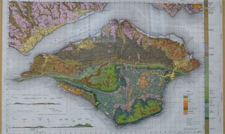
Top photo: Geological map of the Isle of Wight, 1965.
